


Compiled by
Stephen Moore, a 4th Great Grandson
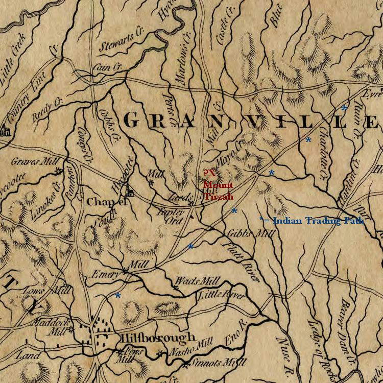
Stephen Moore began the acquisition of his Mt. Tirzah estate on 4 January 1777 when he purchased a tract of 220 (described in the indenture as 265) acres of land in Orange County from Arthur and Elizabeth Moore, no relation to Stephen1. This land had been part of a 365 acre grant made to John Allen Tharp in 1761 by John Earl of Granville. On 27 March of the same year, Stephen bought another Orange County parcel from James Dickins2. This parcel, described in the indenture as 70 acres, was actually 145 acres and comprised the remainder of the 365 acres of the Tharp grant. On 9 May 1777, these parcels became part of the new Caswell County. The two parcels looked like this (measurements in chains, 1 chain = 66 feet):

The property lay on minor tributaries of the Flat River in the western part and was traversed southwest to northeast by the Hillsboro Road.
On 11 July 1778, Stephen laid claim to three parcels of land surrounding his homestead3. His claims were filed in Palmyra and warrants were issued for the parcels to be surveyed. A warrant for the survey of grant 801 was issued on 11 July 1778. This tract was surveyed on 24 December 17784. The State of North Carolina ultimately approved the claims and granted the three parcels of land to Stephen; Grant No. 689 of 640 acres5; Grant No. 691 of 692 acres6; and Grant No. 8017 of 640 acres. The deeds were recorded on 10 November 1784. Grant No. 691 was actually 640 acres as testified to by the 1784 tax list of Caswell County. In that list, Stephen was credited with 2285 acres, the original 365 acres plus 1920 acres in grants.
On 19 January 1788, Stephen purchased a 250 acre parcel from Robert Dickins.8 This parcel was divided by the Deep Creek of the Flat River and contained a ford on that creek for the Hillsboro Road. Stephen purchased a second parcel from Robert Dickins on 17 February 1790 comprising 125 acres lying on small branches of Deep Creek.9 Stephen’s holdings were now 2660 acres. After Stephen’s death, his executors Grizey, Robert and Phillips purchased, on 28 May 1800, an additional 13 ¾ acres from James Cochran, the property described as “on Meadow Br on the Great Road.”10 This parcel, a small triangular plot, lay on the north side of the Helena-Moriah Road.
The estate now comprised 2673¾ acres. The following plat shows the various parcels of Stephen’s estate as of June 1800.

A - 4 January 1777 from Arthur Moore
B - 27 March 1777 from James Dickins
C - 1784 Grant 689
D - 1784 Grant 691
E - 1784 Grant 801F - 19 January 1788 from Robert Dickins
G - 17 February 1790 from Robert Dickins
H – 28 May 1800 from James Cochran
Here is a reasonably accurate rendition of what the estate would have looked like in June 1800.

Stephen’s sons Robert and Phillips had established their own homesteads and their “plantations” are mentioned in Stephen’s will. Stephen’s brother Charles had his home on Stephen’s land, Stephen’s will stating that Charles held a life lease on the land and that it would revert upon Charles’ death. Charles died ca. 1801 and his lease, therefore, does not show in the plats of the division of the estate following Stephen’s death. Stephen’s will suggests that Robert and Phillips had purchased land adjacent to Stephen’s estate. His bequest states, “The plantations now in the respective possession of my sons Robt. Moore and Phillips Moore are hereby confirmed to them as a part of their respective bequest, together with as much land contiguous and convenient to their respective settlements….” Additionally, the descriptions of Mary Stanford’s and Grizey’s parcels in the 1805 survey show that Robert owned property to the north of Stephen’s estate (See attachment K).
Stephen’s will (attachment I) stipulated that his wife Grizey was to receive 1/3rd of the estate and that the remaining 2/3rds was to be equally divided among his children and his sister Ann. The Person County Court met in September 1803 and ordered Jesse Dickins and other Commissioners to divide the estate. Their proposed division of the estate was exhibited in Court in the March term of 1804 and ordered to be recorded.11 That division is shown below:

This is what the parcels would have looked like on an overlay of the topography.

Grizey’s “widow’s dower” was included in the parcels laid out for Samuel, Portius and Sidney. One wonders how this division was concluded as it clearly is not in accordance with Stephen’s will, which stipulated that Grizey would get one-third of the estate and the remaining two-thirds would be equally divided among his children and sister. By August of 1805, it was clear that this division was not working for the legatees, who made the following petition.
State of N. Carolina
[Per]son County
We the undersigned legatees hereby agree that the division of the real estate of the late Genl Stephen Moore by Comm[issioners] appointed by Person County Court be set aside and that the estate be again divided.
August 13th, 1805
Phillips Moore
R. Stanford
Mary Stanford
Robert Moore
Grizey Moore
Ann Moore
Frances Dickins
Jesse Dickins
Of note is the fact that Portius, age 20, did not sign the petition. He stood to lose land in any subsequent division honoring Grizey’s entitlement to one-third of the estate’s land. The other two legatees, Samuel and Sidney, were ages 16 and 10 respectively and not of age to have signed.
The Commissioners met again on 26 and 27 December 1805 and reapportioned the estate. In this division Grizey was allotted one-third of the estate and the remaining two-thirds was equitably divided among the other legatees. A monetary settlement was made among the latter based on the value of the property they were allotted. The plats of this division and the terms of the monetary settlements were exhibited in open court in the March Term 1806 and ordered to be recorded.12 Here is a plat of the 1806 division.

Taking what appear to be the most accurate measurements from the various surveys and the very detailed 1805 survey description of Robert’s parcel on Deep Creek, as well as the configuration of that creek, we can postulate, with reasonable accuracy, what the estate would have looked like following the 1806 division as an outline on the topography.

References:
1-Person County Record Book A, page 81; attachment A.2-Person County Record Book A, page 82; attachment B.
3-In 1777, North Carolina permitted its residents to claim vacant lands that had been owned by the King of England or the Earl of Granville.
4-See attachment L.
5-State of North Carolina Land Grant 689; attachment C.
6-State of North Carolina Land Grant 691; attachment D.
7-State of North Carolina Land Grant 801; attachment E.
8-Person County Record Book E, page 229; attachment F.
9-Person County Record Book G, page 24; attachment G.
10-Person County Deed Book C, p. 230; attachment H. Kendall, Katharine Kerr. Person County, North Carolina Deed Books 1792-1825. Baltimore, MD, USA: Genealogical Publishing Co., 1994.
11-Person County Record Book 3, pages 252-261; attachment J.
12-See attachment K.
Attachments:
A. Indenture, Arthur Moore to Stephen Moore.
B. Indenture, James Dickins to Stephen Moore.
C. Land Grant 689.
D. Land Grant 691.
E. Land Grant 801.
F. Indenture, Robert Dickins to Stephen Moore.
G. Indenture, Robert Dickins to Stephen Moore.
H. James Cochran to executors of Stephen Moore.
I. Stephen’s will.
J. The 1803/4 division of the estate.
K. The 1805/6 division of the estate.
L. Warrant for survey of Grant 801.
Attachment A


Attachment B

Attachment C

Attachment D

Attachment E

Attachment F

Attachment G

Attachment H
230 James Cochran to exec of Stephen Moore namely Grizey Moore, Robert Moore, Phillips Moore all of Person Co., for $46.50, 13 ¾ A on Flat R adj Blakeley on Meadow Br on the great rd. Said land part bequeathed by his father Alexander Cochran, decd, and taken from 2 tracts – 10 A from grant of John Allenthorp 6 Dec 1761 from John Earl Granville; the other to James Blakeley by John Earl Granville 28 Jun 1761. 28 May 1800. Wit: John Clixby, Richd A. Holland.
Attachment I

First I do order and direct that my loving wife Grizey Moore do hold and remain in possession of my homestead plantation with all the buildings and improvements thereon together with as much land contiguous and convenient as to make one full third part of my real estate and also one third part of my Personal Estate agreeable to the laws of the State of North Carolina; in, such behalf made and provided.
The plantation which now is and is to remain in possession of my brother Charles Moore for and during his natural life is to be considered as an allotment for my youngest surviving child and the land to be bounded and extended agreeable to the directions ordered to be observed as to the settlements made by my sons Robert and Phillips—The value of improvement[s] is not to be rated in the estimation of the value of the land, but damages if any, is to be taken into a reasonable estimation; this is directed in consideration of the uncertainty of the time when it may revert to their use, my brother having a life lease with even date of this Will.
Stephen Moore (seal)
To Phillips Moore No. 1 containing 320 acres of land valued at 23/9d per acre – 380 [values are in pounds, shillings and pence]
Woodson Hubbard
The Will of Stephen Moore (1734 1799)
Dated 27 Sept. 1797 – Proved March Term 1800
From Person County Will Book No. 4, pages 342-355

In the name of God Amen.
I, Stephen Moore of Person County in the State of North Carolina, being in health of body and of disposing mind and memory do make this my last Will and Testament.
First I do order and direct that my loving wife Grizey Moore do hold and remain in possession of my homestead plantation with all the buildings and improvements thereon together with as much land contiguous and convenient as to make one full third part of my real estate and also one third part of my Personal Estate agreeable to the laws of the State of North Carolina; in, such behalf made and provided.
My executors are to raise from such part of my Estate as is not otherwise disposed of so much as may be necessary to pay my just and lawful debts and to pay the same with all convenient speed. – My wife Grizey Moore is requested to take upon herself the burden and charge of the guardianship and tuition of our children during their nonage unless any or either of them (having a lawful right thereto) may otherwise choose in their own behalf.
Our elder children having had their nurture and education without charge having been made against them personally it is my Will that a reasonable and equitable proportion of my estate (before a division) be set apart and appropriated to the nurture and tuition of my younger children, the care and tuition of whom is hereby most earnestly recommended to the strict attention of my executors—and (excepting my household and kitchen furniture and wearing apparel) I do order and direct that the rest and residue of my estate, real and personal be apportioned off or made sale of at the discretion of my Executors and fair and equal division be made of the same, or of the value or proceeds thereof between my sister Ann Moore and my children (to wit) Robert Moore, Phillips Moore, Frances Dickens or her lawful representative, Ann Moore, Mary Moore, Portius Moore, Samuel Moore and Sidney Moore and the child or children that may hereafter be born from our wedlock or the survivor or survivors of them; in equal shares; any or either of such shares are nevertheless subject to a deduction or other adjustment, equal to the value of any debt, valuation of real property by any of them possessed of from me, or balance that may appear, that is due either to or from them by my books of account or otherwise. It being always my express Will and desire that my sister Ann Moore and all my children should fairly and equally share and divide the full value of two thirds of [all] my net estate, real and personal, to them or the survivors of them, their heirs and assigns forever—and after the death of my said wife Grizey Moore the other third part is also to be equally divided between all my other legatees herein before particularly named and mentioned, or the survivors of them or their lawful representatives.
[The plantations now in the respective possession of my sons Robt. Moore and Phillips Moore, are hereby confirmed to them as a part of their respective bequest, together with as much land contiguous and convenient to their respective settlements (regard being always to be had that the boundaries and lines be so fixed, as not to do an unreasonable injury to other divisions to be made) as shall be fixed by indifferent judges allotting to each of them their equitable and proportionate value of my Estate to be divided among my aforesaid legatees.]
The plantation which now is and is to remain in possession of my brother Charles Moore for and during his natural life is to be considered as an allotment for my youngest surviving child and the land to be bounded and extended agreeable to the directions ordered to be observed as to the settlements made by my sons Robert and Phillips—The value of improvement[s] is not to be rated in the estimation of the value of the land, but damages if any, is to be taken into a reasonable estimation; this is directed in consideration of the uncertainty of the time when it may revert to their use, my brother having a life lease with even date of this Will.
Again I do constitute and appoint to execute this Will my wife Grizey Moore Executrix and my sons Robert and Phillips Moore Executors—in witness whereof I have hereunto set my hand and seal at Mount Tirzah this twenty-seventh day of September in the year of our Lord one thousand seven hundred and ninety seven – This being my Will written on two sides of paper in my own proper handwriting without erasure, interlination or witness.
Stephen Moore (seal)
Person County March Term 1800
This Will being exhibited in open Court and the handwriting of Stephen Moore dec’d being proved by the oaths of [Jos] Taylor, William Waite and Charles Moore Junr the same was ordered to be entered on record.
Test
Jesse Dickens
Attachment J
March Term 1804, Book 3, p 252
Agreeable to an order of Person Court September 1803 appointing the undersigned and other Commissioners to divide the estate of Genl Stephen More deceased amongst the legatees agreeable to the tenor of his will and (2 wds). The undersigned Commissioners proceeded to divide the estate by consent of the widow and the other legatees who are of full age. In some respects different from the tenor of the will, the manner of which division will appear by the plans herewith presented Viz.
To the widow Mrs. Grizey Moore a small part of the lot No. 3 laid off for Sidney Moore included in the dotted line is subject to the widow’s dower. Also the whole of the two lotts No. 4 drawn by Samuel Moore and No. 5 drawn by Portius Moore is subject to the widow’s dower except what is included in the dotted lines.
To Phillips Moore No. 1 containing 320 acres of land valued at 23/9d per acre – 380 [values are in pounds, shillings and pence]
To Ann Moore Jr. No. 2 containing 317 acres of land valued at 10s per acre – 158/10
To Sidney Moore No. 3 containing 308 acres of land valued at 22/6 per acre – 346/10
To Samuel Moore No. 4 containing 307 acres of land valued at 25s per acre – 383/15
To Portius Moore No. 5 containing 307 acres of land valued at 33/4 per acre – 511/13/4
To Mary Stanford No. 6 containing 307 acres of land valued at 15s per acre – 230/5
To Ann Moore Sr. No. 7 containing 309 acres of land valued at 10s per acre – 154/10
To Robert Moore No. 8 contained 315 acres of land valued at 22/6 per acre – 354/7/6
To Frances Dickins No. 9 contained 336 acres of land valued at 25s per acre – 420
Wm. Cocke
Chas. HolemanWoodson Hubbard
The foregoing division is satisfactory to me in
Behalf of Portius Moore, Samuel Moore and
Sidney Moore I being their guardian.
In witness whereof I have set my hand and seal.
Grizey Moore
March Term 1804
[Plat of land allotted to Phillips Moore]
Person County March Term 1804
[Plat of land allotted to Ann Moore (daughter)]
[Plat of land allotted to Sidney Moore]
The above exhibited in Court
and ordered to be recorded.
Jesse Dickins.
March Term 1804
This plan represents the lott of land laid off for Phillips Moore agreeable to the will of Stephen Moore decd. Beginning at a hickory corner near the Great Road running thence north 15 chains to a red oak thence east 47 chains to a stake thence south 45° east 7 chains to a stake thence south 51 ½ chains to a red oak thence west 60 ½ chains to a red oak Roberts Cate’s corner thence north 38 chains to a stone corner thence east 8 ½ chains to the beginning containing 320 acres of land more or less surveyd the 28th day of Novr 1803.
Chas. Holeman
Person County March Term 1804
The plott of land above was exhibited in open court and ordered to be reco[rded].
Test.
Jesse Dickins
March Term 1804
This plan represents the lott of land drawn for Ann Moore Junr out of the lands of Stephen Moore decd. Beginning at a red oak corner in Gooch’s line thence north 51 ½ chains to a stake thence north 45° west 7 chains to a stake thence east 68 chains to a pine thence south 11 chains to a white oak thence west 4 ½ chains to a pine thence south 42 chains to a red oak thence west 56 ½ chains to the beginning containing 317 acres of land more or less surveyd this 28th of Novbr 1803. Chas. Holeman
Person County March Term 1804
The foregoing plott of land was exhibited in open court and ordered to be recorded.
Jesse Dickins
March Term 1804
This plan represents the lott of land laid off for Sidney Moore agreeable to the will of Stephen Moore deceased. Beginning at a red oak Phillips Moore corner running thence north 18 chains to a stake thence north 56° W 13 chains to a stake in the road [Helena-Moriah Road] thence east 10 ½ chains to a stake in the meadow thence south 2 ½ chains to a stake at the fence thence south 84° E. 26 chains to the middle of the great road [Hillsboro Road] thence east 45 chains to a pine thence north 16 ½ chains to three sowerwoods thence east 46 chains to a pine in Sweanys line thence south 37 chains to a pine thence west 113 chains to the beginning containing 308 acres of land more or less. Surveyd the 28th of Novbr 1803.
Chas. Holeman
NB That part of the above plan which is included within the dotted lines is subject to the widows dower.
Chas. Holeman
Person County March Term 1804
The foregoing plott of land was exhibited in open court and ordered to be recorded.
Test.
Jesse Dickins
[Plat of land allotted to Samuel Moore]
This plan represents the lott of land drawn for Samuel Moore out of the lands of Stephen Moore deceased. Beginning in the road [Hillsboro Road] at the dividing line between him and Portius Moore thence north 84° west 26 chains to a stake thence north 2 ½ chains to a stake thence west 26 chains to a stake thence north 64 chains to a post oak thence east 23 chains to a black oak thence south 21 chains to a post oak thence east 41 ½ chains to the road thence the course of the road to the beginning containing 307 acres of land more or less the whole of which is subject to the dower of Mrs. Moore except what is included in the dotted lines. Surveyd the 29th of November 1803.
Chas. Holeman
March Term 1804
[Plat of land allotted to Portius Moore]
This plan represents the lott of land drawn for Portious Moore out of the lands of Stephen Moore deceased. Beginning in the road [Hillsboro Road] the dividing line between him and Samuel More thence east 45 chains to a pins thence north 55 chains to a black oak thence west 23 chains to a black jack thence north 22 ½ chains to a post oak thence west 17 ½ chains to a post oak thence south 9 ½ chains to a white oak thence west 30 chains to a black oak thence south 21 chains to a post oak thence east 42 chains to a black oak at the road thence the course of the road to the beginning containing 307 acres of land more or less. Surveyd the 29th November 1803. Chas. Holeman
The foregoing plott of land was duly exhibited in open court and ordered to be recorded.
March Term 1804
This plan represents the lott of land drawn for Mary Stanford out of the lands of Stephen Moore decd. Beginning at a black jack running thence north 22 ½ chains to a post oak thence east 67 chains and 90 links to a pine in Persons line thence south 55 ½ chains to a pine in Swaneys line Sidney Moores corner thence west 46 chains to three sowerwoods thence north 33 chains to a black oak thence west 23 chains to the beginning containing 307 acres of land more or less. Surveyd the 29th day of Novbr 1803.
[Plat of land allotted to Ann Moore (sister)]
This plan represents the lott of land drawn for Ann Moore Senr out of the land of Stephen Moore decd. Beginning at a small white oak running thence west 63 chains to a pine Osborn Jeffreys corner thence north his line 54 chains and 82 links to a pine [thence east 13 chains 50 links] thence south 7 ½ chains to a post oak thence east 49 chains and 66 links to a pine knoll and pointers thence south 47 chains and 38 links to the beginning containing 309 acres of land more or less. Surveyd the 30th of November 1803.
Chas. Holeman
March Term 1804
[Plat of land allotted to Robert Moore]
This plan represents the lott of land laid off for Robert Moore agreeable to the will of Stephen Moore deceased. Beginning in the great road [Hillsboro Road] on Stanfords line running thence west 38 ch. 75 links to a small post oak thence north 37 ch. and 88 links to a pine knoll thence east 55 ch. and 54 links to a black oak thence north 26 chains to a pine Clixbys corner thence east 30 chains to Deep Creek thence south down the creek 15 chains thence south 60° east 1 ½ chs. Thence north 60° east 2 1/1 chains thence north 45° east 2 chs. thence south 38° east 4 1/1 chs. thence south 9° east 6 chs. thence south 9° west 8 chs. to the ford of the great road on Deep Creek at a sweet gum corner thence the various courses of the great road as represented by the above plan to the beginning containing 315 acres of land more or less. Surveyd the 31st of Novbr 1803.
Chas. Holeman
This plott of land was duly exhibited in open court and ordered to be recorded.
March Term 1804
[Plat of land allotted to Frances Dickins]
State of North Carolina
In obedience to an order of the Court of Person County December Term 1805 for Commissioners to divide and allot off the real estate of Gen’l Stephen Moore Decd agreeable to his last will and testament among the following legatees. We the undersigned met on the 26th and 27th days of Decr 1805 and did apportion off the following:
No. 1 to Phillips More – 292 acres valued @ 19/6 V. money per acre $949 – to pay $322.92
The foregoing division of lands was exhibited in Open Court and ordered to be recorded.
p. 104

Which is allotted to Phillips Moore by the Commissioners under an Order of Court of December Term 1805 directing them to divide the real estate of Stephen Moore Dec’d.
The foregoing allotment was duly exhibited in open court and ordered to be recorded.
p. 105
Which is allotted to Frances Dickins by the commissioners under an Order of Court of December 1805 directing them to divide the real estate of Gen’l Stephen Moore Dec’d.
Person County March Term 1806
The foregoing allotment of land was exhibited in open court and ordered to be recorded.
p. 107
Which is allotted to Samuel Moore by the commissioners under an order of the Court of December 1805 directing them to divide the real estate of Gen’l Stephen Moore Dec’d.
[Plat of lot 5]
Beginning at a post oak on John Cothran’s line runing north 36 ch 65 links to a hickory thence east seven ch. fifty links to a red oak thence north seventy three ch. fifty links to a pine Robert Moores line thence west fifteen ch. fifty links to a post oak thence north seven ch. fifty links to a pine thence west thirteen ch. fifty links to a pine thence south fifty four ch. eighty two links to a pine thence east ten ch. to a post oak thence south on Micajah Nichols line sixty four ch. to a stake thence east twelve ch. eight links to the first station containing two hundred forty seven acres and 3/10 more or less.
Which is allotted to Mary Stanford by the commissioners under an order of court of Dec. Term 1805 directing them to divide the real estate of Gen’l Stephen Moore Dec’d.
Person County March Term 1806
p. 109
Which is allotted to Ann Moore Junr by the commissioners under an order of Court of Dec. Term 1805 directing them to divide the real estate of Gen’l Stephen Moore Dec’d.
Person County March Term 1806
p. 110

For Herndon Haralson
p. 111
Which is allotted to Ann Moore Senr. By the commissioners under an order of the Court of Decembr Term 1805 directing them to divide the real estate of Gen’l Stephen Moore Dec’d.
Person County March Term 1806
p. 113
[Plat of Grizey’s parcel]
Which was examined by the commissioners under an order of Court of December Term 1805 directing them to divide the real estate of
Person County March Term 1806
p. 114
May 24th, 1806 We the undernamed legatees of Gen’l Stephen Moore dec’d then received from Phillips Moore acting Ex. of the dec’d our several balances remaining due upon one thousand thirty eight dollars and twenty six cents the proportion of each of two thirds of the estate of the Dec’d in certain notes of land, which when discharged & not till then will be in full of such dividend of said estate.

Document copyright © 2009 by Stephen Moore.
[Editor's note: Distance noted in surveys - 1 chain = 22 yards & 80 chains = 1 mile.]
March Term 1804
Chas. Holeman
Person County March Term 1804
The forgoing plott of land was exhibited in open court and ordered to be recorded.
Test.
Jesse Dickins
All the above tract of land represented by this plan is subject to the dower of Mrs. Moore except that part which is included in the dotted lines. Chas. Holeman
Person County March Term 1804
Jesse Dickins
[Plat of land allotted to Mary Stanford]
Chas. Holeman
Person County March Term 1804
The foregoing plott of land was exhibited in open court and ordered to be recorded.
Test. Jesse Dickins
March Term 1804
Chas. Holeman
Person County March Term 1804
The foregoing plott of land was exhibited in open court and ordered to be recorded.
Test.
Jess Dickins
Chas. Holeman
Person County March T. 1804
Jesse Dickins
This plan represents a lott of land drawn for Frances Dickins out of the land of Stephen Moore deceased. Beginning in the great road [Hillsboro Road] running thence east 48 ch + 60 links to a pine in Persons line thence north 13 ½ chs to Persons corner thence east on Persons line 53 chs to his corner black oak thence north 54 chs to a post oak thence west 23 chs. To a red oak thence south 14 chains to a post oak thence west 35 chs. To Deep Creek thence down the creek as the meanders to the public road to a sweet gum corner of Robt Moores lott thence the various courses of said road to the beginning containing 336 acres of land more or less. Surveyed the 31st of November 1803.
Chas. Holeman
Person County March Term 1804
The foregoing plott of land was duly exhibited in open court and ordered to be recorded.
Test.
Jesse Dickins
Attachment K
1806 division of SM’s estate
March Term 1806 Book 4, p 103-114
No. 2 to Frances Dickins – 282 acres do 4/6 do do $211.50 – to receive $414.52
No. 3 to Sidney Moore – 301 acres valued @ 18 V. money per acre - $903 – to pay $276.98
4 to Samuel Moore – 285 acres @ 10 do do - $475 – to receive $151.2
5 to Mary Stanford – 247 acres @13/6 do do - $555.75 – to receive $70.27
6 to Ann Moore Jr. – 292 acres @ 12 do do - $584 – to receive $42.2
7 to Robert Moore – 307 acres @ 18 do do - $921 – to pay $294.98
8 to Portius Moore – 138 acres @ 21 do do $483 – to receive $143.2
9 to Ann Moore Sen – 221 acres @ 15 do do $552.50 – to receive $73.52
Nine legatees 9 / $5634.25
Proportion $626.2 7.9
As will be seen by Plotts accompanying this report given under our hand the day and date above written. Sam. Smith
R. Vanhook
Nath. Norflett
Test. Jesse Dickins

Person County North Carolina
This plan represents a tract of land surveyed by me bounded as follows. Beginning at a pine Sidney Moore corner runing south 53 ch. to a sassafras Jno Gooche’s line thence west 57 ½ ch. to a red oak on R. Cates line thence No. 38 ch. to a stake thence east 8 ch. 50 links to a hickory thence No. 15 ch. to a red oak thence east 49 ch. to the first station containing in all 292 acres more or less. October 10th, 1805
Phillips Moore D.S. [Deputy Surveyor]
For Herndon Haralson
Person County March Term 1806
Test. Jesse Dickins
[Plat of lot2]
Person County North Carolina
This plan represents a tract of land surveyed out of the lands of Stephen Moore Dec’d on the waters of Deep Creek of Flat River – Beginning at a dogwood on Phillips Moores line runing east 64 ch. to a black oak Cozzarts line thence south 6 ch. thirty links to a white oak thence west four ch. fifty links to a pine thence south forty one ch. seventy links to a red oak stump thence west on Gooches line fifty nine ch. fifty links to a sassafras Phillips Moore corner thence north forty eight ch. to the first station containing two hundred and eighty eight acres and 4/10 more or less. October 10th, 1805
Phillips Moore D.S.
For Herndon Haralson
Test. Jesse Dickins
p. 106
[Plat of lot 3]
Person County No. Carolina
This plan represents a tract of land surveyed out of the land of Stephen Moore Dec’d on the waters of Flat River and Deep Creek beginning at a pine southeast of Homestead runing north five ch. twenty links to a black oak thence east forty six ch. to a stake Swineys line thence south on said line thirty one ch. seventy links to a black oak thence west 64 ch. to a dogwood on Phillips Moores line thence north on said line five ch. fifty links to a pine thence west on Phillips Moores line forty nine ch. to a red oak in Cothrans line thence north on said line 18 ch. to a stake in the road thence north 53 deg. west thirteen ch. on the road to a stake thence east ten ch. 50 links to a stake in the field thence south two ch. fifty links to a stake at the fence thence south 84 deg. East 26 chains to a locust thence east forty one ch. to the beginning containing three hundred and one acres and 9/10 more or less.
October 10th, 1805
Phillips Moore D.S.
For Herndon Haralson
Which is allotted to Sidney Moore by the commissioners under an order of the court of December term 1805 directing them to divide the real estate of Gen’l Stephen Moore Dec’d.
Person County March Term 1806
The foregoing allotment was exhibited in open court and ordered to be recorded.
Test. Jesse Dickins
[Plat of lot 4]
Person County No. Carolina
This plan represents a tract of land surveyed out of the lands of Stephen Moore Dec’d on the waters of Deep Creek of Flat River beginning at a red oak on the east end of homestead runing north sixty two ch. ten links to a pine thence east forty six ch. to a dogwood Person’s line thence south sixty two ch. ten links to a stake on Swiney’s line thence west on Sidney Moore line forty six ch. to the first station containing 285 6/10 acres more or less.
October 11th, 1805 Phillips Moore D.S.
For Herndon Haralson
Person County March Term 1806
The foregoing allotment was exhibited in open court and ordered to be recorded.
Test. Jesse Dickins p. 108
Person County No. Carolina
This plan represents a tract surveyed out of the lands of Stephen Moore Dec’d on the waters of Flat River 11th October 1805
Beginning at a post oak on John Cothran’s line runing north 36 ch 65 links to a hickory thence east seven ch. fifty links to a red oak thence north seventy three ch. fifty links to a pine Robert Moores line thence west fifteen ch. fifty links to a post oak thence north seven ch. fifty links to a pine thence west thirteen ch. fifty links to a pine thence south fifty four ch. eighty two links to a pine thence east ten ch. to a post oak thence south on Micajah Nichols line sixty four ch. to a stake thence east twelve ch. eight links to the first station containing two hundred forty seven acres and 3/10 more or less.
Phillips Moore
For Herndon Haralson
The foregoing allotment was exhibited in court and ordered to be recorded.
Test. Jesse Dickins
[Plat of lot 6]
Person County No. Carolina
This plan represents a tract of land surveyed out of the lands of Stephen Moore Dec’d on the waters of Flat River beginning at the road [south ?] of the lane runing north 43 deg. west twenty one ch. sixty links to a pine thence west twenty one ch. twenty links to a red oak thence north seventy three ch. 50 links to a pine in Robert Moores line thence east thirty four ch. twenty six links to a stake thence south forty seven ch. thirty eight links to a white oak thence south 30o east twenty four ch. ten links to a white oak on the Hillsb. Road thence the road south fourteen deg. west fifteen ch. thence south 33o west five ch. thence south 45o west five ch. to the first station containing two hundred & ninety two acres & 2/10 more or less. October 11th, 1805.
Phillips Moore
For Herndon Haralson
The foregoing allotment was exhibited in court and ordered to be recorded.
Test. Jesse Dickins

Person County No. Carolina
This plan represents a tract of land surveyed out of the lands of Stephen Moore Dec’d. on the waters of Deep Creek beginning at a sweet gum road ford runing nearly north on the creek sixteen ch. to the [crook?] of the creek thence north two ch. fifty links to the line of Abner Williams to a dogwood thence west to the creek seven ch. to an ash thence north on the creek fifteen ch. to a horn beam [tree] thence west thirty ch. to a pine thence south twenty six ch. to a stake in Robert Moores field thence west thirty nine ch. forty five links to a red oak thence south thirty seven ch. eighty eight links to a black oak thence east twenty three ch. to a pine at the road thence the road north 44 o east five ch. thence north 51 o east fifteen ch. thence 79 o east nine ch. thence north 74 o east five ch. thence north 54 o east five ch. thence north 35 o east twenty ch. thence north 55 o east three ch. thence south 83 o east eight ch. to the first station containing three hundred seven and 8/10 acres more or less.
October 11th, 1805 Phillips Moore D.S.For Herndon Haralson
Which is allotted to Robert Moore by the commissioners under an order of Court of Dec. Term 1805 directing them to divide the real estate of Gen’l Stephen Moore Dec’d.
Person County March Term 1806
The above allotment was exhibited in open court and ordered to be recorded.
Jesse Dickins
[Plat of lot 8]
Person County No. Carolina
This plan represents a tract of land surveyed out of the lands of Stephen Moore Dec’d on the west side of Deep Creek beginning at a pine on the Hillsb. Road runing east one ch. seventy five links to a pine thence south ten ch. to a pine thence east forty six ch. to a dogwood thence north twenty three ch. fifty links to a black oak Person’s corner thence east six ch. fifty links to the creek corner on a white oak thence up the course of the creek twenty one ch. fifty links to a sweet gum at the road ford Robert Moore’s corner thence north 85 o west eight ch. thence south 55 o west three ch. thence south 35 o west twenty ch. thence south 54 o west five ch. thence south 74 o west five ch thence south 79 o west nine ch. thence south 51 o west fifteen ch. thence south 44 o west three ch. to the first station containing one hundred & thirty eight 3/10 acres more or less.
October 11th, 1805 Phillips Moore D.S.
For Herndon Haralson
Which is allotted to Portius Moore by the commissioners under an order of Court of Dec. Term 1805 directing them to divide the real estate of Gen’l Stephen Moore Dec’d.
Person County March Term 1806
This allotment of land was exhibited in open court and ordered to be recorded.
Test. Jesse Dickins
p. 112
[Plat of lot 9]
Person County No. Carolina
This plan represents a tract of land surveyed out of the lands of Stephen Moore Dec’d. on Deep Creek of Flat River beginning on Person’s line at an ash on the creek runing east forty six ch. fifty links to [?] thence north fifty four ch. to a pine thence west twenty three ch. to a red oak Abner William’s line thence south fourteen ch. to a post oak William’s corner thence west on William’s line twenty five ch. to a dogwood Robert Moore’s corner thence south on Robert Moore’s line two ch. fifty links to the creek thence [south]
The creek thirty seven ch. fifty links to the first station containing two hundred & twenty one acres & 1/5 more or less.
October 11th, 1805 Philips Moore D.S.
For Herndon Haralson
The above allotment was exhibited in open court and ordered to be recorded.
Test. Jesse Dickins
[Plat of Grizey’s parcel]
This plan represents a tract of land surveyed out of the lands of Stephen Moore Dec’d on the waters of Flat River & Deep Creek for Grizey Moore. October 11th, 1805. Beginning at a pine in Sidney Moore’s land runing north seventy seven ch. thirty links to a pine near the cross of Hillsb. & Tapp roads thence west on Robert Moore’s line twenty five ch. to a black oak thence north twenty seven ch. eighty eight links to a black oak on Robert Moore’s line he bought of Cocke thence west sixteen ch. 10 links to a stake thence south forty seven ch. 38 links to a white oak thence south 30o east 24 ch. ten links to a white oak on the road thence the road south 14 o west fifteen ch. thence south 33 o west five ch. thence south 45 o west 5 ch. to the foot of the lane thence north 43 o W. twenty one ch. sixty links to a pine thence west 28 ch. 70 links to a hickory thence south thirty six ch. sixty five links to a post oak on Jn. Cothran’s line thence east fourteen ch. to a stake in the field thence south two ch. 50 links to a stake at the fence thence south 84o E. twenty six ch. to a locust thence east forty one ch. to the first station containing four hundred & ninety seven 6/10 acres more or less.
Phillips Moore
For Herndon Haralson
Gen’l Stephen Moore Dec’d.
The foregoing allotment was exhibited in open court and ordered to be recorded.
Test.
Jesse Dickins
June Term 1806
May 24th, 1806 We the undernamed legatees of Gen’l Stephen Moore Dec’d then
on settlement acknowledged the receipt of one thousand thirty eight dollars & twenty six cents in lands and other property our full apportionment of two thirds of the estate of the Dec’d which we each and severally received.
Jesse Dickins
Robert Moore
Phillips Moore
The aforesaid acknowledgement was ackd in open court and ordered to be recorded.
Test. Jesse Dickins
Ann Moore Junr
R. Stanford
Portius Moore
Person County June Term 1806
The [terms?] of the foregoing receipt was ackd in open court and ordered to be recorded.
Test.
Jesse Dickins
Attachment L

Document copyright © 2009 by Stephen Moore.
[Editor's note: Distance noted in surveys - 1 chain = 22 yards & 80 chains = 1 mile.]